Trail Walking Les Planches-en-Montagne - Les Planches En Montagne 30 juil 2019 CAF - Photo

Les Planches En Montagne 30 juil 2019 CAF

© OpenStreetMap contributors
Length
Length
22 km
Max alt
Max alt
1075 m
Uphill gradient
Uphill gradient
576 m
Km-Effort
Km-Effort  
29 km
Min alt
Min alt
697 m
Downhill gradient
Downhill gradient
578 m
Boucle
Boucle
Yes
Creation date :
2019-07-30 07:16:20.193
Updated on :
2019-12-10 10:53:22.778

(0 Reviews)

Walking
Walking
6h55
Difficulty : Medium

Scan this QR Code to open this trail in the SityTrail application

FREE GPS app for hiking

Logo SityTrail SityTrail

IGN / Geographical institutes

Download SityTrail from the App Store Download SityTrail from Google Play

Logo SityTrail SityTrail World

The world is yours!

Download SityTrail from the App Store Download SityTrail from Google Play Download SityTrail on Huawei AppGallery

About

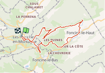
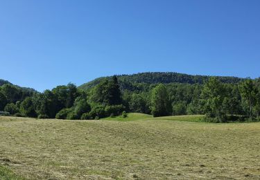
Trail Walking of 22 km to be discovered at Bourgogne-Franche-Comté, Jura, Les Planches-en-Montagne. This trail is proposed by TRIMAILLE.

Description

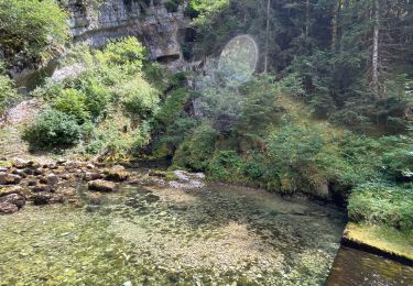
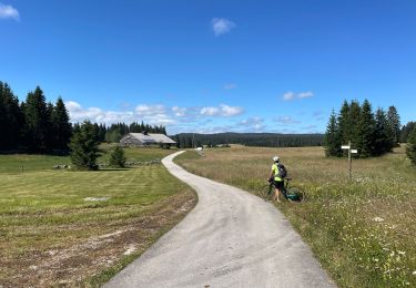
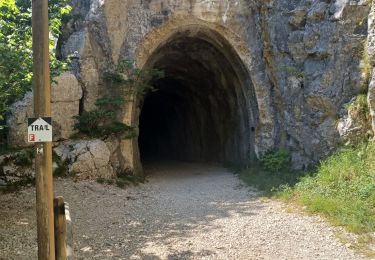
Départ au parking des Gorges de la Langouette. Monter au village, puis au refuge du Paradis. Rejoindre le belvédère du Couillou, puis celui de la Roche Fendue. Descendre  en empruntant le sentier botanique sur la source de la Saigne. Rejoindre Foncine le Haut et traverser le village. Passage à proximité de la source du Bief de la Ruine. Passer dans l'ancien tunel de chemin de fer. Au sortir du tunnel, cascade du bief de la Ruine. Redescendre sur Les Planches en montagne. A la chapelle, dans le village prendre la rue à droite qui conduit au gorges de la Langouette. Suivre le chemin aménager qui longe les gorges et fini sur le parking.

Elevation profile

Photos

28 photos in total. Please click on a photo to see them all in the gallery.

Positioning

Country:
France
Region :
Bourgogne-Franche-Comté
Department/Province :
Jura
Municipality :
Les Planches-en-Montagne
Location:
Unknown
Start:(UTM)
270883 ; 5171296 (32T) N.

Trails nearby

Trail Walking Les Planches-en-Montagne - Gorges de la Saine - Les Planches en Montagne - Photo
Walking
tracegps

Walking

Easy
(3)
Les Planches-en-Montagne, Bourgogne-Franche-Comté, Jura, France
6.1 km | 8.1 km-effort
2h 30min
Yes
Trail Walking Les Planches-en-Montagne - à la découverte de la languette  - Photo
Walking
YannickPFENDT

Walking

Very easy
(2)
Les Planches-en-Montagne, Bourgogne-Franche-Comté, Jura, France
2.3 km | 2.7 km-effort
41min
Yes
Trail Walking Les Planches-en-Montagne - Les planches en Montagne - Saine et langouette - Photo
Walking
marcel.F

Walking

Medium
(3)
Les Planches-en-Montagne, Bourgogne-Franche-Comté, Jura, France
10.1 km | 13.5 km-effort
3h 2min
Yes
Trail Walking Foncine-le-Haut - Circuit Creux Maldru - Photo
Walking
FOUCAULT

Walking

Foncine-le-Haut, Bourgogne-Franche-Comté, Jura, France
14.7 km | 20 km-effort
5h 32min
Yes
Trail Mountain bike Foncine-le-Haut - Jura 2 - Photo
Mountain bike
cbenoit38

Mountain bike

Very difficult
Foncine-le-Haut, Bourgogne-Franche-Comté, Jura, France
37 km | 46 km-effort
4h 20min
No
Trail Mountain bike Foncine-le-Haut - Jura 1 - Photo
Mountain bike
cbenoit38

Mountain bike

Difficult
Foncine-le-Haut, Bourgogne-Franche-Comté, Jura, France
32 km | 40 km-effort
4h 45min
Yes
Trail Walking Foncine-le-Bas - Foncines-le-Bas, du viaduc des Douanets à  la cascade du Bief de la Ruine. - Photo
Walking
Mady Lambert

Walking

Easy
Foncine-le-Bas, Bourgogne-Franche-Comté, Jura, France
3.6 km | 4.9 km-effort
2h 21min
Yes
Trail Walking Chaux-des-Crotenay - Autour du plateau de chaux des Crotenay - Photo
Walking
zefreefly

Walking

Medium
Chaux-des-Crotenay, Bourgogne-Franche-Comté, Jura, France
18.5 km | 26 km-effort
4h 17min
Yes
Trail Walking Les Planches-en-Montagne - Montliboz - Gorges de la Langouette  - Photo
Walking
Marie-Claire-mcp

Walking

Medium
Les Planches-en-Montagne, Bourgogne-Franche-Comté, Jura, France
6.3 km | 8.6 km-effort
2h 8min
Yes


Close
My subscriptions